


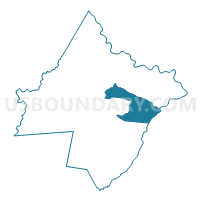
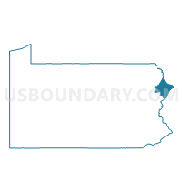
DINGMAN TWP DIST 01, Pike County, Pennsylvania
About
Outline

Summary
| Unique Area Identifier | 663666 |
| Name | DINGMAN TWP DIST 01 |
| County | Pike County |
| State | Pennsylvania |
| Area (square miles) | 35.91 |
| Land Area (square miles) | 34.71 |
| Water Area (square miles) | 1.20 |
| % of Land Area | 96.65 |
| % of Water Area | 3.35 |
| Latitude of the Internal Point | 41.32432700 |
| Longtitude of the Internal Point | -74.89425540 |
Maps

Graphs
Select a template below for downloading or customizing gragh for DINGMAN TWP DIST 01, Pike County, Pennsylvania


Neighbors
Neighoring Voting District (by Name) Neighboring Voting District on the Map
- BLOOMING GROVE TWP Voting District, Pike County, PA
- DELAWARE TWP PCT NORTH, Pike County, PA
- DINGMAN TWP DIST 02, Pike County, PA
- MILFORD Voting District, Pike County, PA
- MILFORD TWP Voting District, Pike County, PA
- Montague township voting district 1, Sussex County, NJ
- Montague township voting district 2, Sussex County, NJ
- Sandyston township voting district 1, Sussex County, NJ
- SHOHOLA TWP Voting District, Pike County, PA
Top 10 Neighboring County Subdivision (by Population) Neighboring County Subdivision on the Map
- Dingman township, Pike County, PA (11,926)
- Delaware township, Pike County, PA (7,396)
- Blooming Grove township, Pike County, PA (4,819)
- Montague township, Sussex County, NJ (3,847)
- Shohola township, Pike County, PA (2,475)
- Sandyston township, Sussex County, NJ (1,998)
- Milford township, Pike County, PA (1,530)
- Milford borough, Pike County, PA (1,021)
Top 10 Neighboring Place (by Population) Neighboring Place on the Map
- Pocono Woodland Lakes CDP, PA (3,209)
- Gold Key Lake CDP, PA (1,830)
- Sunrise Lake CDP, PA (1,387)
- Milford borough, PA (1,021)
Top 10 Neighboring Elementary School District (by Population) Neighboring Elementary School District on the Map
- Montague Township School District, NJ (3,847)
- Sandyston-Walpack Township School District, NJ (2,014)
Top 10 Neighboring Secondary School District (by Population) Neighboring Secondary School District on the Map
Top 10 Neighboring Unified School District (by Population) Neighboring Unified School District on the Map
Top 10 Neighboring State Legislative District Lower Chamber (by Population) Neighboring State Legislative District Lower Chamber on the Map
- General Assembly District 24, NJ (215,703)
- State House District 189, PA (76,401)
- State House District 139, PA (67,006)
Top 10 Neighboring State Legislative District Upper Chamber (by Population) Neighboring State Legislative District Upper Chamber on the Map
Top 10 Neighboring 111th Congressional District (by Population) Neighboring 111th Congressional District on the Map
Top 10 Neighboring Census Tract (by Population) Neighboring Census Tract on the Map
- Census Tract 9506.06, Pike County, PA (6,079)
- Census Tract 9506.05, Pike County, PA (5,847)
- Census Tract 3710, Sussex County, NJ (3,847)
- Census Tract 9507.02, Pike County, PA (3,579)
- Census Tract 9501.02, Pike County, PA (2,475)
- Census Tract 3719, Sussex County, NJ (2,014)
- Census Tract 9505.01, Pike County, PA (1,656)
- Census Tract 9506.01, Pike County, PA (1,530)
- Census Tract 9506.03, Pike County, PA (1,021)
Top 10 Neighboring 5-Digit ZIP Code Tabulation Area (by Population) Neighboring 5-Digit ZIP Code Tabulation Area on the Map
- 18337, PA (14,572)
- 18428, PA (12,012)
- 18328, PA (7,759)
- 07827, NJ (4,244)
- 18458, PA (3,017)
- 18425, PA (1,354)
- 07851, NJ (119)